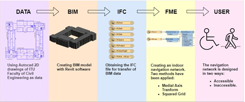
The purpose of the Building Information Modelling Based Fire Evacuation Simulation (YBIMS) project is to virtualize the human behaviors, environment and process steps during a fire evacuation to improve the decision making process for fire evacuation scenarios. All stages, methods and the conceptual model will be tested at the Istanbul Technical University, Civil Engineering Building.
The purpose of the Building Information Modelling Based Fire Evacuation Simulation (YBIMS) project is to virtualize the human behaviors, environment and process steps during a fire evacuation to improve the decision making process for fire evacuation scenarios. All stages, methods and the conceptual model will be tested at the Istanbul Technical University, Civil Engineering Building.
You can find the detailed explanation about the project, coordinated by Prof. Dr. Hande Demirel, below.


Project Title: Building Information Modelling (BIM) Based Fire Evacuation Simulation
Project Type: TÜBİTAK-1001
Project Coordinator: Prof. Dr. Hande Demirel
Abstract:
People living in cities spend most of their time in complex and crowded buildings, where risks they encounter are also specific to these closed areas. Among these risks; fires, due to the rapid spread of flame and smoke, is categorized as a disaster, where half of the deaths occur due to inhalation of smoke and toxic gases. Hence, building fire evacuation management is of utmost importance. The traditional fire risk reduction methods, smoke, toxic gases, objects, obstacles and structural risks that may be caused by fire cannot be dynamically addressed. For this reason, performing evacuation analyzes based on various fire scenarios by using advanced technologies is critical in terms of preventing/reducing losses. The current developments in Information Technologies make possible to develop a real-time evacuation simulation platform that can be used for decision support purposes, where dynamic risk management and human movement/interaction can be digitalized in a virtual environment that various what-if scenarios can be tested.
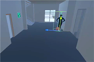
The purpose of the Building Information Modelling Based Fire Evacuation Simulation (YBIMS) project is to virtualize the human behaviors, environment and process steps during a fire evacuation to improve the decision making process for fire evacuation scenarios. The project consists of four main stages: a) production of a three-dimensional Building Information Model (BIM), which includes geometric and semantic information required emergency management, automatization of data acquisition via implementing machine learning techniques b) the spread of flame/fire and smoke is simulated where an integrated three-dimensional dynamic risk map and associated dynamic indoor navigation routes is modelled, c) behaviors and interactions of people during the evacuation process is modelled via spatial / non-spatial decision functions of self-adaptive agent-based modelling d) generating evacuation simulations under various what-if scenario by considering the dynamic changes caused by the disaster and the evacuation process accordingly. All these stages, methods and the conceptual model will be tested at the Istanbul Technical University, Civil Engineering Building. For the success of project, an inter-disciplinary team of experts will collaborate, where a detailed management plan and work plan are presented in the project.
The YBIMS project is innovative since; a) a comprehensive, innovative and tailor-made solution will be brought to the two-dimensional static fire evacuation plans, where interdisciplinary knowledge and experience are integrated b) by using real-time maps for dynamic risk management, evacuation scenarios can be tested in a virtual environment without risking human life, c) data from different sources will be integrated into the international standard three-dimensional Building Information Model (BIM), fire simulation, three-dimensional risk maps and agent-based modeling will be integrated into the same platform to make possible of interdisciplinary interaction. d) Necessary level of detail will be determined for BIM based fire evacuation simulation. e) The YBIMS project is unique in the national and international literature, especially because of the dynamic risk method and the decision-making capabilities of digital actors in the simulation environment as a result of their interaction with each other and/or building and fire/smoke.
The scientific and economic impact of the YBIMS project is high. Within YBIMS, a 3D dynamic, agent-based digital simulation model and a 3D spatial database of the building will be produced. The building fire evacuation systems will be integrated in terms of disciplines, knowledge and models. The final product could be used holistic or modular manner within the campus and in other complex and crowded buildings (such as hotels, hospitals, airports, shopping malls) for risk management and risk reduction. YBIMS aims to publish nationally/internationally in scientific journals and conferences with high impact factors. Research capacity will be increased by supporting doctorate and master theses. After accomplishing the aims of the YBIMS project, the developed simulation platform will be the key asset to new national-international projects.