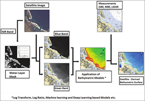
In this study supported by TUBITAK, an 'Experimental' Satellite-based Bathymetry Model will be constructed for the Horseshoe Island shallow waters. Within the scope of the performance analysis, comparative tests will be carried out with the Landsat-8 and Sentinel-2 satellite datasets, whose resolution has been increased through Generative Adversarial Networks', and the satellite data obtained with the national satellite Göktürk.
You can find the detailed explanation about the project, coordinated by Assoc. Prof. Dr. Uğur Algancı, below.

Project Title: Satellite-Derived Bathymetry Modelling in Shallow Water: A Case Study of Horseshoe Island
Project Number: TUBİTAK-121Y366
Project Coordinator: Assoc. Prof. Dr. Uğur Algancı
Abstract:
Apart from being important for nautical navigation, shallow water bathymetry also plays a crucial role in monitoring coastal regions in order to detect and identify high anthropogenic pressure and the effects of climate change, such as sea level rise. The use of single (SBE) and multi-beam echo sounders (MBE) is the traditional method for surveying seas and oceans; yet this method poses a couple of drawbacks, e.g.: loses its effect as the depth decreases, suffers from limited spatial coverage and temporal resolution, subjects to logistical constraints, corresponds to high operational costs and risks.
With the help of recent advancements, space borne remote sensing techniques have become an alternative approach for the extraction of bathymetric data in the coastal zones, owing to their ability to acquire data over large spatial areas and to provide high frequency temporal monitoring. The method developed to survey shallow waters is called Satellite-derived Bathymetry (SDB).
In contrast to the traditional methods, SDB requires no mobilization of personnel and equipment, and delivers rapid bathymetric data, thus saves time and cost.
Satellite-based bathymetry method, which has increased in popularity as of 2018, has gained the identity of an official map data source in 2020 with the updates made in the relevant documents and standards of the International Hydrographic Organization (IHO).
In this study, an 'Experimental' Satellite-based Bathymetry Model will be constructed for the Horseshoe Island shallow waters. Within the scope of the performance analysis, comparative tests will be carried out with the Landsat-8 and Sentinel-2 satellite datasets, whose resolution has been increased through Generative Adversarial Networks', and the satellite data obtained with the national satellite Göktürk.
For the extraction of spectral reflectance values from satellite images and calculation of bathymetric data, 'Logarithmic Transformation', 'Logarithmic Ratio', 'Support Vector Machines', 'Random Forest' and 'Convolutional Neural Network' models will be prepared.
Multi-beam Sonar data collected in the region within the scope of the National Antarctic Science Expeditions will be used for the training and post-inference verification process of these models.